Underway the Edusat Challenge of the Government of Catalonia to analyze the impact of climate change in the classroom using satellite data
• The Edusat Challenge aims to introduce Earth observation in the classroom through didactic proposals that take advantage of the satellite images from the Copernicus programme of the European Space Agency (ESA)
• 34 teachers from 31 educational centres throughout Catalonia have participated in the training programme, which aims to empower teachers to encourage their students’ interest in scientific and technological disciplines
• Promoted by the Departments of Business and Work and of Education and Professional Training of the Generalitat de Catalunya, the Edusat Challenge is an initiative of the Geographic Information Systems and Remote Sensing Service (SIGTE) of the Universitat de Girona (UdG), with the collaboration of the Institute of Space Studies of Catalonia (IEEC)

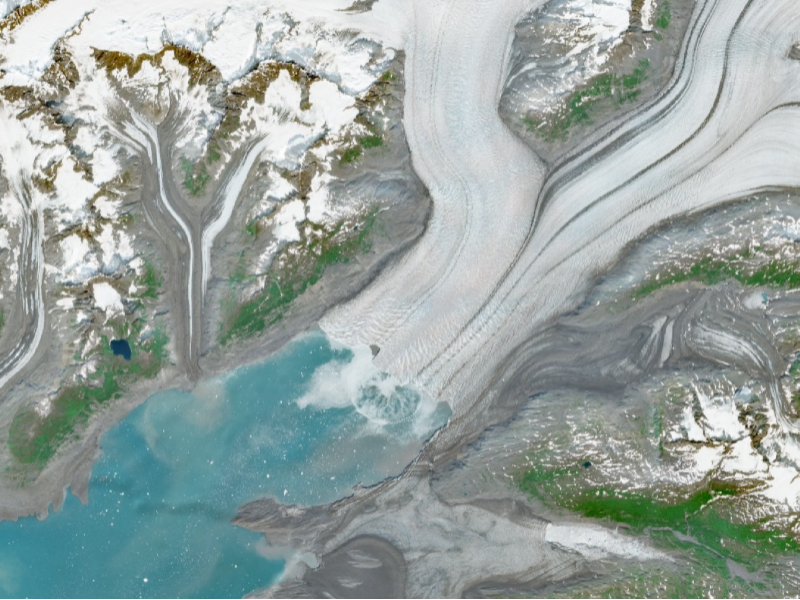
Caption: Image captured by the Sentinel 2 satellite of the Copernicus program of the European Space Agency (ESA).
Credits: ESA. Contains modified Copernicus Sentinel data (2023).
Up to 34 high school, secondary school and primary school (upper cycle) teachers from 31 educational centres in 27 municipalities throughout Catalonia have participated during November in the specialized training in the use of satellite images that kicked off the Edusat Challenge, a pilot programme that offers training and guidance to teachers in order to introduce Earth observation in the school and high school classrooms.
The aim of the programme is to empower teachers to develop a teaching proposal based on the exploration and processing of satellite images and related to the challenges of global environmental change, and thereby transfer it to the classroom with the ultimate goal of encouraging students’ interest in STEM (science, technology, engineering and mathematics) and digital disciplines.
Once completed the teachers’ training phase, the programme will continue from this January with the release of the challenge and the implementation of an Earth observation activity in the classroom by the trained teachers, who will be mentored and accompanied throughout the process. Finally, in mid-May, there will be a final presentation of the results of this first year of pilot program.
The Edusat Challenge is promoted by the Departments of Business and Work —through the Secretariat of Digital Policies—and Education and Professional Training of the Generalitat de Catalunya, within the framework of the NewSpace Strategy of Catalonia and the STEAMcat programme, based on the Edusat platform developed by the Geographic Information Systems and Remote Sensing Service (SIGTE) of the University of Girona (UdG) to offer materials and training on remote sensing to university students and some high capacity schools. The program also counts with the collaboration of the Institute of Space Studies of Catalonia (IEEC).
A training plan for teachers with a real and measurable impact in the classroom
The potential use of the Edusat programme in educational centres brings a whole range of opportunities and makes it possible to work on mathematical skills (algebra, geometry and statistics), as well as on natural, social and geographic skills (use and interpretation of maps and different data), in addition to improving digital, technological, teamwork and critical data analysis skills.
In the first year of the pilot programme, the theme around which the 40-hour training programme for teachers of STEM and Social Sciences subjects has been articulated is water and its management. Therefore, it is proposed to investigate case studies related to this topic: drought episodes, floods, snowmelt, rivers, reservoirs, seas and oceans around the world.
Edusat programme will allow students to identify and monitor different phenomena of interest involving significant surface changes using satellite images from the Copernicus programme of the European Space Agency (ESA). Copernicus is a European initiative that offers, in a free, public and open way, data and images in real time of our planet and the environment thanks to the Sentinel satellites. These images allow the identification of natural phenomena such as fires, floods, glacial retreat, volcanic eruptions or deforestation, both on a local and global scale.
Thanks to Edusat and the technological resources provided to educational centres, it will be possible to observe sustained changes in the territory from the classroom, such as the retreat of the Ebro delta, the effects of river and gorge flooding during floods, detect different urban growth processes or observe air pollution data in large cities, among others.
Contacts
IEEC Communication Office
Castelldefels, Barcelona
E-mail: comunicacio@ieec.cat
About the IEEC
The Institute of Space Studies of Catalonia (IEEC — Institut d’Estudis Espacials de Catalunya) promotes and coordinates space research and technology development in Catalonia for the benefit of society. IEEC fosters collaborations both locally and worldwide and is an efficient agent of knowledge, innovation and technology transfer. As a result of more than 25 years of high-quality research, done in collaboration with major international organisations, IEEC ranks among the best international research centres, focusing on areas such as: astrophysics, cosmology, planetary science, and Earth Observation. IEEC’s engineering division develops instrumentation for ground- and space-based projects, and has extensive experience in working with private or public organisations from the aerospace and other innovation sectors.
The IEEC is a non-profit public sector foundation that was established in February 1996. It has a Board of Trustees composed of the Generalitat de Catalunya, Universitat de Barcelona (UB), Universitat Autònoma de Barcelona (UAB), Universitat Politècnica de Catalunya · BarcelonaTech (UPC), and the Spanish Research Council (CSIC). The IEEC is also a CERCA centre.
