ieec | other
‘Menut’ already operates from space to help improve land management and combat the effects of the climate crisis
• The Earth Observation nanosatellite of the NewSpace Strategy of Catalonia successfully closes the commissioning stages and we already regularly receive processed images of Catalonia
• Images captured by ‘Menut’ since February and up to now in its passage over Catalonia have been improving in quality and definition
• Technical teams from the IEEC, the Cartographical and Geological Institute of Catalonia and Open Cosmos continue to work together to refine the quality of ‘Menut’ data and to be able to apply it to intended use cases

Credits: IEEC – ICGC – Generalitat de Catalunya
Half a year after its launch, ‘Menut’ (which means ‘small’, in Catalan), the second satellite mission, and the first Earth Observation mission, of the NewSpace Strategy of Catalonia promoted by the Government of Catalonia, already captures data to help improve the management of the territory and help to control and combat the effects of the climate crisis, while regularly sending images of Catalonia. After successfully overcoming the various commissioning stages, ‘Menut’ has already entered operations and is ready to fulfil its main objective: from now on images from Catalonia will be received weekly.
Developed by the company Open Cosmos under the supervision of the Institute of Space Studies of Catalonia (IEEC — Institut d’Estudis Espacials de Catalunya), and with the advice and technical support of the Cartographic and Geological Institute of Catalonia (ICGC), the nanosatellite ‘Menut’ orbits the Earth since last 3 January at a speed of about 8 km per second and passes over Catalonia every 5 days approximately. It boards a state-of-the-art camera that allows it to record images around 5 metres of resolution from anywhere on the planet, although prioritising the obtention of images from the Catalan territory. Having been calibrated, processed and analysed, these images will allow the territory to be monitored, especially with the impacts of climate change in mind.
Since its launch into space, ‘Menut’ has successfully passed the planned initial configuration stages, calibration tests and commissioning of all its subsystems before entering service. As early as February, with the arrival of the first images, the technical teams have used the data captured by ‘Menut’ on a regular basis to prepare the instruments on board.
First images of Catalonia
The many images taken since February have been improving in quality and definition thanks to the work of the ICGC, OpenCosmos and the IEEC teams within the framework of the NewSpace Strategy of Catalonia. In addition to those acquired over Catalonia, the nanosatellite has taken images of many other parts of the world which, on the one hand, will help to combat climate change on a global scale and, on the other, put ‘Menut’ in the world-wide scene of Earth Observation.
Some of the images captured by Menut so far are:

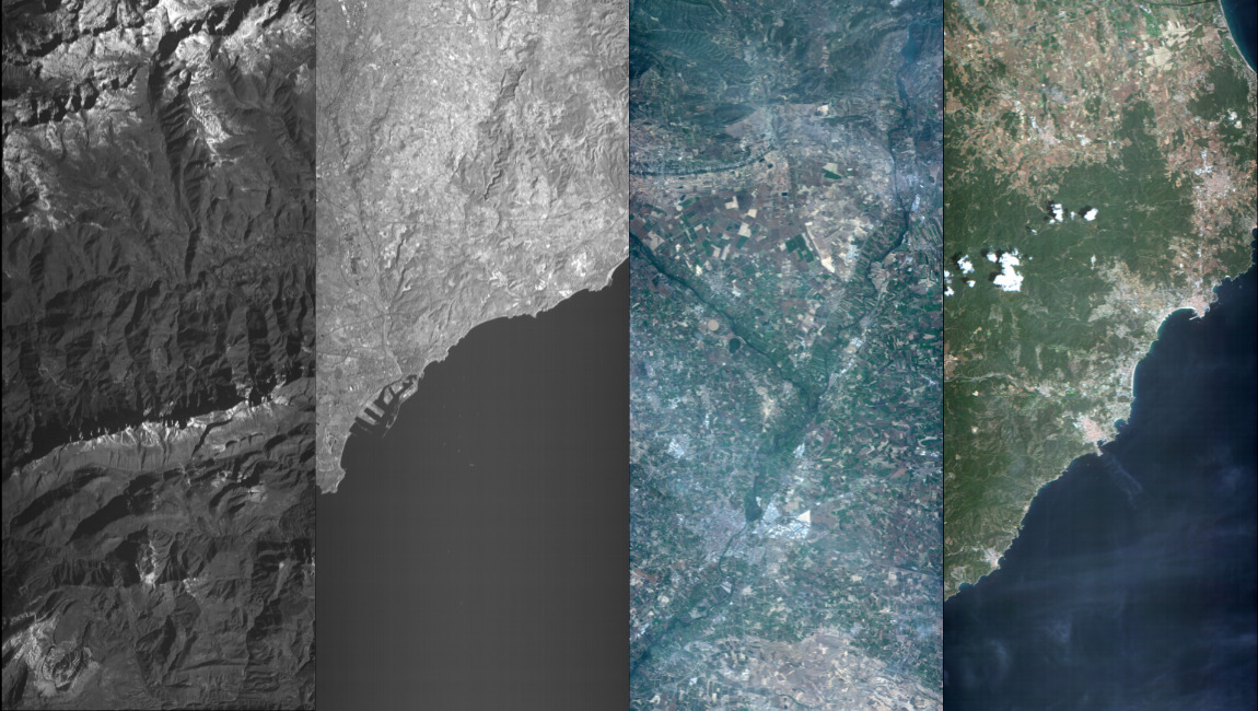
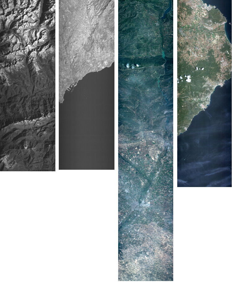
Pedraforca and Tarragona (infrared) (images on the left, 1 and 2). The first images of ‘Menut’ over Catalonia were acquired on 18 February. The first image corresponds to the Cerdanya area, where the Pyrenees can be seen at the height of Lles de Cerdanya, the Cerdanya valley and part of the Cadí-Moixeró Natural Park up to the Pedraforca. On the second one, taken on the same day, the city of Tarragona can be seen and even a boat can be observed. These are uncalibrated images acquired in an initial phase of the nanosatellite commissioning process.
Lleida (RGB). On 16 May, an image of Pallars Jussà, Noguera and Segrià was obtained. Much of the Segre river basin and Horta de Lleida can be observed. Future acquisitions in the same area will serve to assess the impact of drought on crops and contribute to improving water management.
Palafrugell (RGB) (image on the right). This image of the area of Empordà, from Escala to Tossa de Mar, was acquired on 25 June. It shows how ‘Menut’ data have an impact on the applications related to the monitoring and delimitation of the effects caused by extreme weather events such as floods, flash floods, and river sediments plumes in coastal waters. Work areas such as biotype monitoring or policies and actions linked to water quality and landscape resilience will be favoured.
Image collection from ‘Menut’ available here.
Image acquisition and processing
Open Cosmos manages the ‘Menut’ operations from its headquarters in Barcelona, where the flight team, from the Mission Control Centre, handles daily satellite operations, ensuring fluid communication with ‘Menut’, anomalies detection and correction, and flight software updates.
Subsequently, within the framework of the mission of the NewSpace Strategy of Catalonia, the images are sent to the ICGC, which is responsible for applying the specific corrections and processes (geometric and atmospheric), essential to transform them into useful information.
In addition, the ICGC works to introduce ‘Menut’ data into its usual processing of Earth Observation data obtained from other sources, to generate specific or dedicated products. These products meet the needs of the territory, such as areas particularly vulnerable to the effects of climate change. The Ebre Delta, the Muga basin, the Maresme coast or Pla d’Urgell are some of these areas, especially chosen for their diversity in representing challenges in areas such as biodiversity, resource management or socio-economic effects.
‘Menut’ will also allow applications in areas related to the forest masses and their management, such as forest fires; planning and monitoring of urban and natural ecosystems; water management, and monitoring, control and protection of the environment and activity in coastal areas.
The corrected data from the ‘Menut’ will soon be available to the public, the research community and the industry, on an open access discovery and download platform that the ICGC is building within the framework of the NewSpace Strategy of Catalonia.
In parallel, under the supervision and coordination of the Government of Catalonia, the IEEC, ICGC and Open Cosmos teams continue to work together to refine the quality of ‘Menut’ data, with tasks of coordination and maintenance of data quality that will be repeated periodically throughout the lifetime of the nanosatellite.
About the NewSpace Strategy of Catalonia
‘Menut’ is the second satellite mission of the NewSpace Strategy of Catalonia promoted by the Government of Catalonia through the Department of Business and Work, and the first that has Earth observation as its mission to contribute to improving land management and to help control and combat the effects of the climate crisis.
The Strategy, which is designed to take advantage of the opportunities of this new economic field based on the use of small satellites and the exploitation of their data, is supported by the IEEC, ICGC and the i2CAT Foundation as promoters and aims to project and connect the Catalan space ecosystem with other innovation poles around the world to place it on the international game board linked to this new emerging area.
About the IEEC
The Institute of Space Studies of Catalonia (IEEC — Institut d’Estudis Espacials de Catalunya) promotes and coordinates space research and technology development in Catalonia for the benefit of society. IEEC fosters collaborations both locally and worldwide and is an efficient agent of knowledge, innovation and technology transfer. As a result of more than 25 years of high-quality research, done in collaboration with major international organisations, IEEC ranks among the best international research centres, focusing on areas such as: astrophysics, cosmology, planetary science, and Earth Observation. IEEC’s engineering division develops instrumentation for ground- and space-based projects, and has extensive experience in working with private or public organisations from the aerospace and other innovation sectors.
The IEEC is a non-profit public sector foundation that was established in February 1996. It has a Board of Trustees composed of the Generalitat de Catalunya, Universitat de Barcelona (UB), Universitat Autònoma de Barcelona (UAB), Universitat Politècnica de Catalunya · BarcelonaTech (UPC), and the Spanish Research Council (CSIC). The IEEC is also a CERCA centre.
Contacts
IEEC Communication Office
Barcelona, Spain
E-mail: comunicacio@ieec.cat
